Trails and Parks of Big Canoe
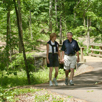
Big Canoe is host to many beautiful parks, each with its own appeal, special features and lovely trails. These trails range from broad paved paths to forest footpaths, meandering among trees, streams and meadows.
There are maps in the kiosks at the main entrances to the trails. Be sure to stop there to see all the details and features about the trails and parks. The trail names match the color of their corresponding trail. Bicycles may use the paved and gravel trails. North is up on all the maps.
When hiking, be mindful of the trail lengths and carry water as needed. It is a good idea to take your cell phone along with the emergency numbers.
To view maps of the trails and parks of Big Canoe, click on the pdf file below.

|
Trails & Parks of Big Canoe.pdf Size : 1942 Kb Type : pdf |
To learn when and what wildflowers will be in bloom and on which trail, click on the pdf file below.
|
|
Wildflower Bloom Chart.pdf Size : 8 Kb Type : pdf |
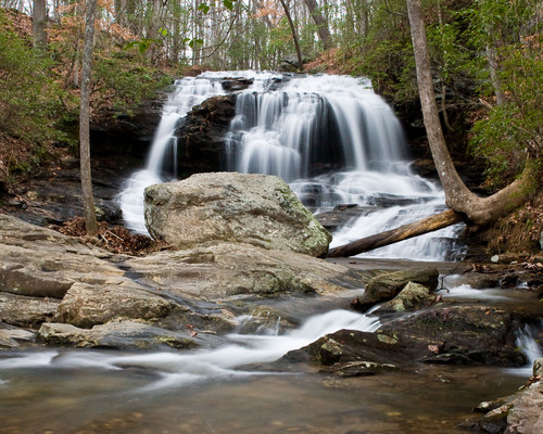
Lower Falls
Blackwell Creek Trail
Length: 1 mile
Difficulty: Easy to Moderate - at one point there is a steep embankment with steps. If you are concerned with the difficulty, it is easier to hike if entered near the Scout Hut.
Features: The trail follows along Blackwell Creek with the water flowing over the rocks in the stream. Walking through a mature forest with many large hemlocks is a relaxing experience. This trail features benches with meditation books and Bibles in the small boxes near the benches.
This trail follows through the
How to get there: Traveling north on
Covered Bridge Trail
Length: 2 miles round trip
Difficulty: Moderate; at one point there is a steep hillside with several steps.
Features: One of the most beautiful areas on all the trails in Big Canoe awaits you at the end of this trail. In an area that is green year round because of the Canadian Hemlock, rhododendron and mountain laurel surrounding you, Blackwell Creek flows over a rock ledge and around huge boulders creating an awesome setting. Below the water cascade is a large rock in the middle of the creek. The creek is forced through a narrow channel in the rock creating a masterful display of nature at work. This rock is a great place for a picnic or just to sit and hang your feet in the water absorbing nature around you. Consider shedding your shoes and wading in the creek between the picnic rock and the waterfall. It feels great during a warm
A reminder of the past of this area will greet you as you walk alongside the creek below the Covered Bridge. You will see stacked stone columns that are the remnants of the supports for a bridge estimated to be over a century old. Look closely in the undergrowth between Blackwell Creek and
This is an enjoyable hike in any season. Wildflowers grace many parts of the trail in the Spring and Summer, especially in the area just after you cross
How to get there: Traveling north on
Indian Rocks Park Trail
Length: Total length 0.8 miles; divided into three (3) trails.
· Indian Mounds Trail is 0.3 miles,
· Indian Mounds Loop Trail is 0.2 miles and the
· Lake Petit Trail is 0.3 miles
Difficulty: Easy
Features: You do not want to miss the "Indian Rocks". Multiple round, stone stacks built by native Americans cover the hillside near the start of Indian Rocks Park Trail. Stop to read the signs and speculate on why and when the structures were built. You can then follow the small stream down to
Indian Mounds Trail begins at the parking area on Woodland Trace and ends at Quail Cove. Indian Mounds Loop Trail has a blue blaze and forks to the left from the Indian Mounds Trail when you cross the stream eventually rejoining the Indian Mounds Trail. The Lake Petit Trail is the continuation of the Indian Mounds Trail across Quail Cove to
Getting There: The easiest way to find this trail is to cross the Petit Lake Dam, stay right at the fork onto Petit Ridge, turn right on Quail Cove, then left onto Woodland Trace. Parking is available on Woodland Trace across from the intersection with Little Beaver.
Jeep Trail
Length: 2 miles, but this can be divided into segments to meet your desires.
Difficulty: Easy - unpaved road
Features: Walk, jog, or bicycle on an unpaved road that parallels Disharoon Creek through a broad, flat valley. If the grandchildren are along, let them wade in the clear waters of Disharoon Creek at the crossings. Don't forget to look for your favorite animal tracks in the muddy areas along the road.
Disharoon Cabin was originally located in the woods to the right of the entry road to Sconti Restaurant, off
On the left of the Jeep Trail, where the Lower Falls Trail crosses, are rock mounds built by either pioneers or native Americans. The purpose or origin of these mounds is not known.
Also along the Jeep Trail is "The Diggings". These are probably the result of backbreaking labor with pick and shovel by some long-forgotten prospector, perhaps in search of gold. It is also possible that the Cherokee Indians who were native to the area created the diggings.
Toad's Glen near the
Just before you reach the
You will not have any trouble finding the
Between the Lower and
Last but not least on the hit parade for the Jeep Trail is the
Getting There: You can access the Jeep Trail in three places:
Wilderness Parkway: Parking is available between the intersections of
Mountain Mint: At the end of Mountain Mint
Yellow Root: Two parking spaces are available at the end of Yellow Root (off Indian Pike). A path leads from the parking spaces down to the Jeep Trail.
Nancy Womack Trail
Length: A total of 0.8 miles
Difficulty: Downstream of Valley View this trail is easy. Be careful of the stream crossings, rocks can be slippery. Upstream of Valley View, the trail eventually becomes steep - but is well worth the effort. One note of caution: there is a healthy growth of poison ivy on the last leg of this trail approaching the view of the falls. You should consider wearing long pants when hiking this trail.
Features: This trail, named in memory of an avid hiker and a strong supporter of the hiking trails of Big Canoe, is one of the most beautiful trails in Big Canoe. The upper end of the trail follows a small, very clear, rapidly moving stream up a valley with steep hills on either side. You feel that you are alone with nature. You will cross the stream in multiple spots and will be fascinated as the stream runs over the rocks and creates mini-waterfalls. The grand finale of the trail is a bench overlooking
How to get there: The Nancy Womack Trail can be accessed from Valley View or from the Jeep Trail near the
From Valley View: The stream and trail cross Valley View at the lowest point between Huckleberry and
From the Jeep Trail near the
Upper Falls Trail
Length: 0.8 miles
Difficulty: Moderate
Features: Walk along a very secluded area surrounded by a plethora of native evergreens. You will follow a small stream and enjoy the ferns growing in the moist areas under the towering hardwoods.
This trail culminates in the beautiful
How to get there: There are two ways to reach the Upper Falls Trail:
Mountain Mint: Park at the end of Mountain Mint and follow the Jeep Trail to the access point for the
From the Lower Falls Trail: Follow the Lower Falls Trail to the
Lower Falls Trail
Length: A hike of 1.7 miles from
Difficulty: Moderate - Most of this trail is easy to hike, but there are some hills you will traverse.
Features: Following the course of Disharoon Creek, this trail exposes you to the wide variety of flora and fauna inhabiting Big Canoe. All through the warmer months, but especially in April, May and June, you will see wild flowers, shrubs and trees in bloom. You may also see the occasional fawn and hear the call of young birds still in the nest.
However, don't think all the fun is in the Spring. Hanging your toes in the cool waters of Disharoon Creek in the Summer or seeing nature cloaked in the color of the changing season in the Fall is another great time to enjoy this trail. Many of us don't hike in the Winter because it is too cold. But once you see the icicles that form where water cascades over the rocks, you may decide that this season is worth your efforts too.
The Grand Finale of this trail is the
One caution, moss makes the rocks along the edges slick, so don't try to get too close.
Getting There: There are several ways to access the Lower Falls Trail:
From the Fitness Center, access the trail to the left of the indoor tennis court. Continue along this trail past
Wilderness Parkway: Parking is available between the intersections of
Cabin Loop Trail
Length: 0.2 miles
Difficulty: Easy
Features: The Cabin Loop joins the Jeep Trail and the Lower Falls Trail. This is a great trail to take your time and explore. One arm of the trail follows alongside a small stream. Not only can you enjoy the sounds of running water, but along stream banks are one the best places to see the native flowers in season. You can explore the pioneer cabin and imagine living with a family of 10 or 12 in a home the size of some of today's living rooms. On the other hand, sit on the porch and imagine the tranquility they had that we have lost so much of today.
How to get there: The Cabin Loop Trail can be accessed at the cabin on the Jeep Trail. By parking on Yellow Root and walking down the access path, you will emerge at the cabin. You can also access this trial off the Lower Falls Trail between the
Wildflower Trail
Length: One Mile
Difficulty: Easy, very flat area
Features: Originally designed to showcase the wildflowers that grow in moist, natural forests, this area has been transformed over time by the tornado of November 2002 and over-grazing by Big Canoe's plentiful deer.
Originally designed to showcases the wildflowers that grow in moist, natural forests, this area has been transformed over time by the tornado of November 2002 and over-grazing by Big Canoe's plentiful deer.
How to get there: There are two ways to reach the Wildflower Trail:
Wilderness Parkway: Parking is available between the intersections of
From the Fitness Center, access the trail to the left of the indoor tennis court. Continue along this trail around the upper end of
Length: 0.6 miles
Difficulty: Easy/Moderate
Features: Hike along the edge of
Getting There: Park at the
McDaniels Meadows
Length: 2.5 miles
Difficulty: Easy - reasonably flat with crushed stone paths. If you approach from the parking lot in the Wildcat Recreation Area, there is one steep hill to climb.
Features: Wander along side a perfusion of wild flowers whose colors change with the bloom pattern of the season. Don't forget to linger on the small bridge near the parking lot to appreciate the plants, amphibians and fish along and in the stream. A don't miss part of McDaniel Meadows is where it crosses Yanegwa Path. This is a heavily shaded, moist area, with lots of ferns. Take time to observe how the stream has eroded the soil away from the roots of the trees leaving them standing on "fingers" along the stream edge. If your dog comes with you, they will enjoy a romp without a leash in the dog park. Bicycles are allowed on the paths in McDaniel Meadows.
Getting There: The parking for McDaniel Meadows is along
Wildcat Trails
Difficulty: Easy - there are some rolling hills, but overall it is an easy walk or a nice workout on a bicycle.
Features: Paved paths for bicycles, jogging or walking wander through meadows of wildflowers from Spring through Fall. Portions of the paths are through woods areas along streams. Stop on the bridges to look at the flora along the streams, it is worth your time. Many dogs enjoy these paths and it is not unusual to encounter deer.
How to get there: Access with parking is available at two sites:
Wildcat Recreation Area Parking Lot (on
On
Waterford Lakes Trail
Length: 1.2 miles
Difficulty: Easy - moving from the lower lake to the upper lake is a little steep.
Features: The Waterford Lakes Trail loops around two small lakes featuring nesting waterfowl on small islands in the lower lake. If you look closely, you can see bream, crappie and bass floating among the tree tops remaining along the lake edges. In the Fall, the dam is covered with wild flowers.
How to get there:
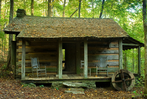
Disharoon Cabin accessible by Cabin Loop Trail or the Jeep Trail.